GOSPORTWX.COM
Gosport Indiana's Only LIVE Weather Station
76°F
Good Morning! Today is Sunday June 22, 2025
Gosport, Indiana, USA
Updated:  22-Jun-2025 7:00am 
  Clear Temperature: 75.6°F Colder 0.7°F than last hour.   -0.7°F/hr Humidity: 92%Increased 1.0% since last hour. Dew Point: 73.1°FDecreased 0.3°F since last hour. Wind: -  0 mph Gust: 0 mph Barometer: 30.10 inHgRising 0.01  inHg/hr  Rising slowly Rain Today: 0.00 in UV Index: 0.0  None

Navigation

  • Search GosportINWX
  • Home
  • Midwestern Weather Network
  • Alternate Pages
    • Mobile App
  • Radar
    • WU Radar Maps
    • US Ridge Radars
    • GR3 Radar
    • NCAR Local Radar
    • MRMS Viewer
    • Interactive Radar
    • US Radar Sites
    • NWS Radar/Threats
      • WPC 6Hr. Radar Analysis
  • Satellite Loops
    • Combined GOES E & W Color Loops
      • Color US 4 Hour Loop
      • Color US BIG 12 Hour Loop
    • GOES19 Satellite Loops
    • Atlantic & Pacific Tropical Loops
    • US & Regional Loops
    • SSEC Global Basin Loops
  • NOAA Radios
  • Recent Weather
    • Hourly Roundup
    • Recent Precipitation
      • US Precipitation Maps
      • Snowfall Maps
        • Current & Past Snowfall Measured
        • Current Snowfall Interpolated
        • Interactive Maps
    • Recent Local Data
      • Indianapolis Airport Past 72 Hours
      • Temp. History
      • Wind History
      • Rain History
    • 24 Hour Temperature Changes
      • Area Maps
      • US Past 12 Hours
    • Storm Reports
      • National
      • Local
  • Winter Weather
    • 3 Day Predicted
    • PQPF Probability of Snow
    • Wind Chill Forecast
    • Current & Past Snowfall Measured
    • Current Snowfall Interpolated
    • Interactive Maps
    • Winter Storm Severity Index
  • Forecasts, Advisories, & Alerts
    • NWS Forecasts
      • Local Forecasts
        • Text Forecast
        • NWS Forecast Map
        • WU-Forecast
        • Graphical Forecasts
        • Forecast Models
      • US Front Maps
        • US Static
        • Day 1-3 Fronts
        • Day 3-7 Fronts
      • US Forecast Maps
        • US Forecast Maps
        • Precipitation
          • QPF 3 Day Loops
          • 3 Day Freezing Precip. Loops
          • 7 Day Forecast
        • Lightning & Convection
        • Winter 3 Day Lows
        • US Graphical
        • Regional Forecast Loops
      • Weather Stories
        • WFO Stories
    • Snow Day Predictor
    • Jet Sream Forecasts
      • WeatherForYou
      • StormSurfing
      • Global Orthographic
    • EHWO from CRH
    • NWS WFO Text Products
    • NWS US Advisory Map
    • NWS Alerts
    • Advisory Log
    • UV Index Forecast
    • Fire Danger
      • USFS Wildfire Danger
  • NWS Centers
    • Weather Prediction Center
      • Current 24 Hour Surface Analyses
      • Current 24 Hour Analysis Loops
      • Excess Rain Potential
      • Winter 3 Day Lows
      • Winter Weather Verification
      • River Flood Outlook
    • Storm Prediction Center
      • SPC Overview
      • Convective Outlooks
      • Mesoanalysis
        • Mesoanalysis Maps & Links
      • HRRR Model Browser
      • Severe Weather Probabilities
        • Today & by Day
      • Tornado History
        • Tornado Environment Browser
      • Watch Summaries
        • Recent Severe Watch Summaries
        • Historical Watch Summaries
      • Past Daily Maps
      • Experimental Pages
        • Storm Opportunities
        • SREF
    • 'Climate' Prediction Center
      • CPC Outlook
      • Near-Term Outlook
      • Long-Term Outlook
      • Wind Chill Outlook
    • Hurricane Center
      • Atlantic Region
      • Pacific Region
    • Meteorological Development Laboratory
      • LAMP 24 Hour Temperature Forecast Maps
      • LAMP 24 Hour Lightning Forecast Maps
      • GFSX-MOS Graphics
      • Hi-Rez MOS Forecasts
      • GMOS Forecasts
    • Environmental Lab
      • Environmental View
  • Wind & Forecast Charts
    • Dark Sky
    • Wind & Forecasts
    • Ventusky Charts
  • River Levels
    • Local
    • WPC River Flood Outlook
  • Astronomy
    • Brief Sun-Moon Almanac
    • Space Weather
      • Brief Space Weather
      • Alternate Space Weather
      • Insights MARS Weather
      • NASA Solar Wind Prediction
      • NASA Aurora Borealis Prediction
  • Almanac
    • Current Trends
    • Station Graphs
    • Earthquake activity
    • Nearby METAR Reports
  • Lightning
    • Blitzortung
      • Blitzortung Real Time
      • Live
    • 24 Hour Forecast Lightning & Convection
    • Blitzortung USA
    • StrikeStar
      • Web Site
    • GOES-16 Plots
  • Travel & Road Conditions
    • Local Air Traffic
    • INDOT Travel Advisories
  • Weather Underground
    • PWS Data
  • Drought Pages
    • US Drought Monitor
    • Animated Maps
    • Indicator Map
    • CPC Outlook
    • NISDIS Drought Portal
    • USGS Water Watch
    • USGS Water Watch 7 Day
  • Air Quality
    • US Air Quality
    • Fire and Smoke
  • NASA Earth Observatory
  • World Extremes
  • On This Day
  • US Flu Maps
  • US Noise Levels
  • Pollen
    • Pollen Index
  • Miscellaneous
    • Lawn & Gardening
    • About
    • Useful Links
    • Station Status
    • Version Control

External Links

  • Indiana Roads
  • MitchellWX.com
  • WUnderground
  • WXforum.net
  • personal weather station
  • Midwestern Weather Network
  • REMC
  • Duke Energy
  • Trained Spotter
  • USA Weather Finder

Mobile WX

  • QRCode App Center DroidIphone

Alerts

Owen County
  Details for Owen County Heat Advisory

UNL and Climate Prediction Center Drought Monitors

Animated US Drought Maps


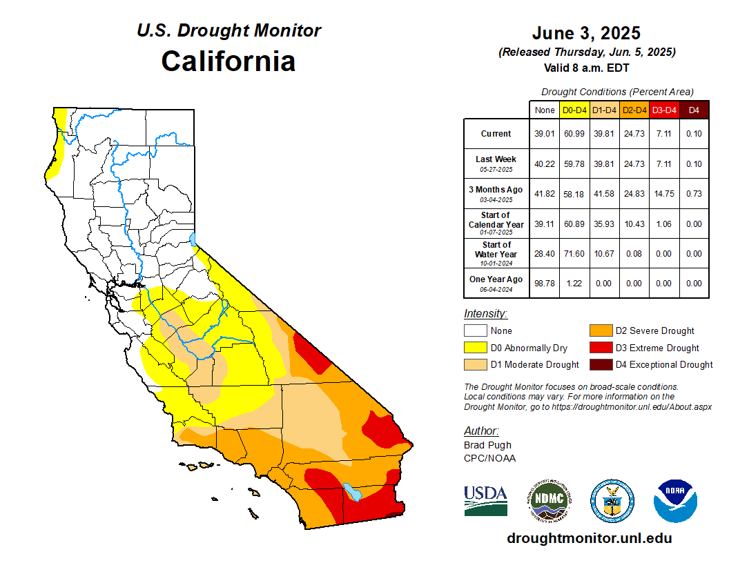
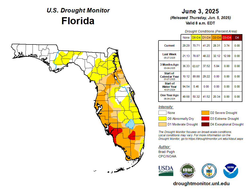
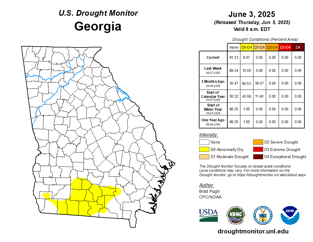
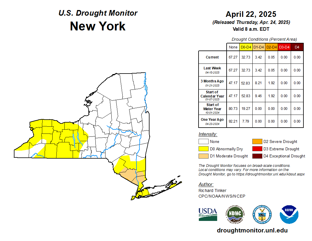
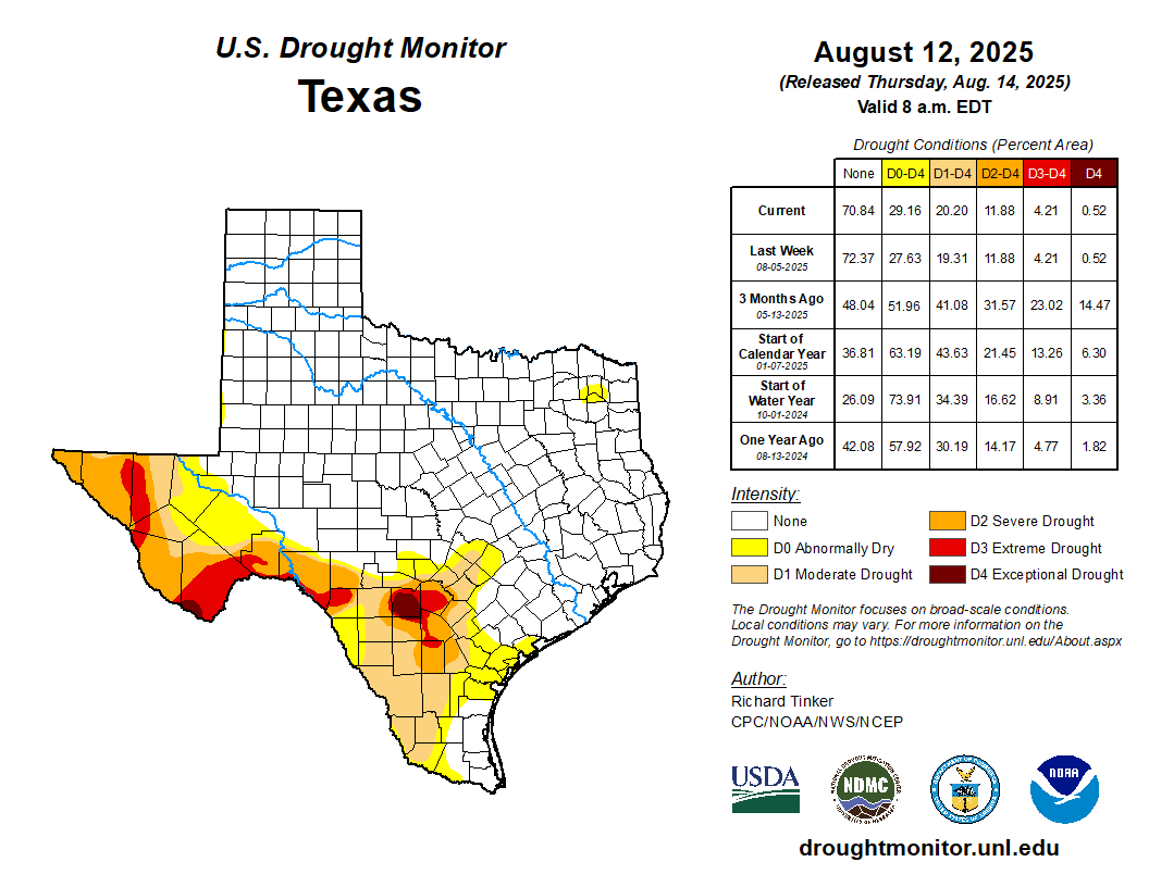
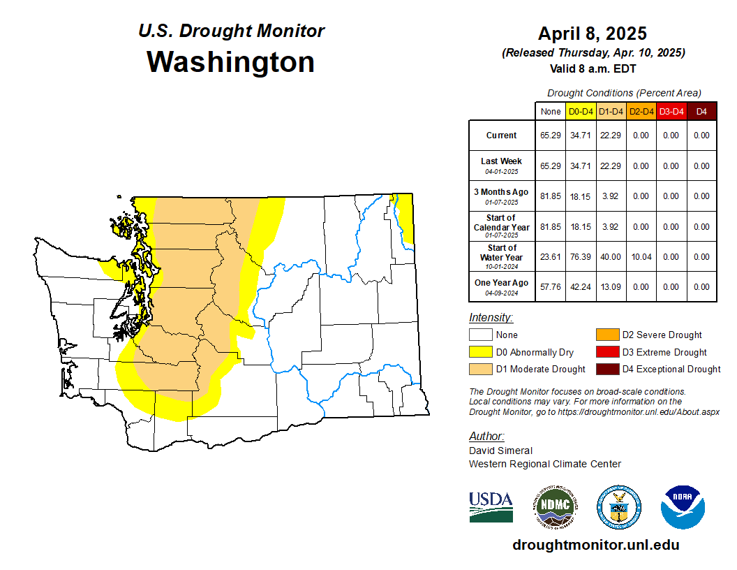
Drought Maps by State

United States 
Alabama
Alaska
Arizona
Arkansas
California
Colorado
Connecticut
Delaware
Florida
Georgia
Idaho
Hawaii
Illinois
Indiana
Iowa
Kansas
Kentucky
Louisiana
Maine
Maryland
Massachusetts
Michigan
Minnesota
Mississippi
Missouri
Montana
Nebraska
Nevada
New Hampshire
New Jersey
New Mexico
New York
North Carolina
North Dakota
Ohio
Oklahoma
Oregon
Pennsylvania
Rhode Island
South Carolina
South Dakota
Tennessee
Texas
Utah
Vermont
Virginia
Washington
West Virginia
Wisconsin
Wyoming
United_States Alabama Alaska Arizona Aransas California Colorado Connecticut Delaware Florida Georgia Hawaii Idaho Illinois Indiana Iowa Kansas Kentucky Louisiana Maine Maryland Massachusetts Michigan Minnesota Mississippi Missouri Montana Nebraska Nevada New_Hampshire New_Jersey New_Mexico New_York North_Carolina North_Dakota Ohio Oklahoma Oregon Pennsylvania Rhode_Island South_Carolina South_Dakota Tennessee Texas Utah Vermont Virginia Washington West_Virginia Wisconsin Wyoming
Default State


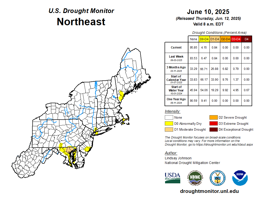
Drought Maps by Region

United States  | Southeast | Northeast | Midwest | High Plains | West | South
United_States Southeast Northeast Midwest High_Plains West South
Default Region


Seasonal Drought Tendency

Percent of Precip for the Year


Monthly Drought Tendency

Percent of Precip for the Year


Palmer Index

Palmer Index


Crop Moisture

Crop Moisture


Precipitation Needed to End Drought

Precip Needed to end Drought


Weekly Weather and Crop Bulletin PDF


Images and Data from UNL Drought Monitor,the USDA and the NWS Climate Prediction Center.
Web Page Created by Dacula Weather and Modified by SE Lincoln Weather.

Top | Contact Us
© 2013-2024 GosportWx.com | CumulusMX (3.28.5-b3282)

Never base important decisions that could result in harm to people or property on this weather information. Always have a backup method of receiving weather information such as a battery powered weather radio..
website uptime