|
Updated: @
30-Jul-2026 2:35pm - next update at 2:40pm
|
| Summary / Temperature |
Wind |
Rain |
Cloud Level |

|
Few Clouds
|

|
84.5°F

Warm
Feels like:
86°F
24-hr difference
1.1°F |
| |
Today |
Yesterday |
| High: |
85.5°F
2:08pm
|
86.4°F
3:39pm |
| Low: |
58.9°F
7:15am
|
59.8°F
5:52am |
|

|


|
NNW
2
Gust:
9 mph
|
|
1 Bft -
Light air
|
|
Today:
17 mph
1:13pm
|
|
Gust Month: 30 mph
July 3
|
|
| Rain Today: |
0 in
|
| Rain Rate (/hr): |
0 in
|
| Rain Yesterday: |
0 in
|
| This Month: |
1.76 in
|
| Season Total: |
32.99 in
|
|
3 days since last rain. |
|
|
| Humidity & Barometer |
Almanac |
Sun/Moon |
| Humidity: |
49 %
 |
| Dew Point: |
63.2°F
|
| Barometer: |
30.07 inHg
|
| Baro Trend: |
Falling slowly
|
|
| Sunrise: |
6:45am |
| Sunset: |
9:01pm |
| Moonset: |
7:37am |
| Moonrise: |
9:47pm |
|
Sunlight:
Today:14 h 15 m 46 s
(Noon)

(Midnight)
|
|
Waning Gibbous |

|
98%
Illuminated |
|
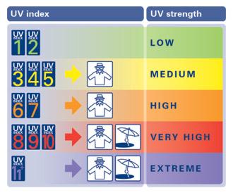
| UV Index Forecast |
Severe Weather Outlook |
|
|
30-Jul-2026 |
|
8.9
Very High |
|

|