


| NWS WEATHER ALERTS | |
|
|
Click Image For Visible Satellite |
Click Image For Radar Loop |
 |
 |
| Updated: @ 09-Jun-2026 8:45pm - next update at 8:50pm | |||||||||||||||||||||||||||||||||||||||
| Summary / Temperature | Wind | Rain | Cloud Level | ||||||||||||||||||||||||||||||||||||

|
|
|
|
||||||||||||||||||||||||||||||||||||
| Humidity & Barometer | Almanac | Sun/Moon | |||||||||||||||||||||||||||||||||||||
|
|
|
|||||||||||||||||||||||||||||||||||||
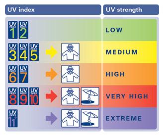
| UV Index Forecast | Severe Weather Outlook | ||||||||||||||||||||||||||||||||||||||
|

| ||||||||||||||||||||||||||||||||||||||


| NWS Weather Forecast - Outlook: Tonight & Wednesday | ||||||
|
||||||
| Countdown to Summer | ||
|