


WXSkyTrackerHD Local Radar
[10/10]

The above image was produced by GRLevel3 software using NEXRAD Radar data from station KIND.
Radar Legend
Clear Air Mode: U.S. radar stations operate in either 'Clear Air Mode' when there is no precipitation in the area or 'Precipitation Mode' when rain is in the area. Radar is at its most sensitive state of operation when in clear air mode. The antenna rotates at its slowest rate permitting the radar to sample a given volume of the atmosphere longer giving it the ability to detect smaller objects than when in precipitation mode. Much of what you see in clear air mode is airborne dust & particulate matter.
Precipitation Mode: Radar doesn't need to be as sensitive as in clear air mode. This is because rainfall provides plenty of returning signals giving you a much cleaner view of any rainfall in the area without all of the clutter seen in clear air mode.
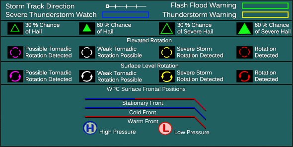
Storm Tracks: The Storm Track Feature allows you to see what direction or track the storm is currently headed to. This feature shows a white line extending out of a little white square box from the center of a storm cell. The "x"'s along this white line indicate every 15 minutes where the center of the storm is forecast to be, based on its current speed and direction. For an example, the 4th "x" shows where the storm will be in an hour given its current tracking. The longer the white line the faster the storm is moving.
Note: Typically you will see area temperatures, current earthquakes, and highway markers etc when there is no rainfall in the area. When there is rainfall occurring in the area the map is usually cleared to only show the radar, highways and city names, along with rain related icons like hail and cloud rotation on the map. This is because we don't want to put up anything extra that will obstruct the view of the radar during any rainfall event.