|
Updated: @
28-Apr-2024 9:25am - next update at 9:30am
|
| Summary / Temperature |
Wind |
Rain |
Cloud Level |

|
Few Clouds
|

|
69.7°F

Comfortable
Feels like:
70°F
24-hr difference
-2.7°F |
| |
Today |
Yesterday |
| High: |
71.3°F
12:39am
|
79.4°F
3:00pm |
| Low: |
67.9°F
7:03am
|
63.6°F
2:42am |
|

|


|
S
4
Gust:
20 mph
|
|
1 Bft -
Light air
|
|
Today:
39 mph
3:47am
|
|
Gust Month: 55 mph
April 2
|
|
| Rain Today: |
0 in
|
| Rain Rate (/hr): |
0 in
|
| Rain Yesterday: |
0.01 in
|
| This Month: |
7.87 in
|
| Season Total: |
18.17 in
|
|
1 day since last rain. |
|
|
| Humidity & Barometer |
Almanac |
Moon |
| Humidity: |
75 %
|
| Dew Point: |
61.4°F
|
| Barometer: |
30.06 inHg
|
| Baro Trend: |
Rising slowly
|
|
| Sunrise: |
6:50am |
| Sunset: |
8:37pm |
| Moonrise: |
12:54am |
| Moonset: |
9:42am |
|
|
Waning Gibbous |

|
79%
Illuminated |
|
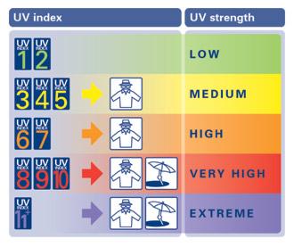
| UV Index Forecast |
Severe Weather Outlook |
|
|
28-Apr-2024 |
|
8.7
Very High |
|

|